STREET GRIDS OF NEW YORK
Understanding the order and underlying ecosystems of New York City.
INTRODUCTION
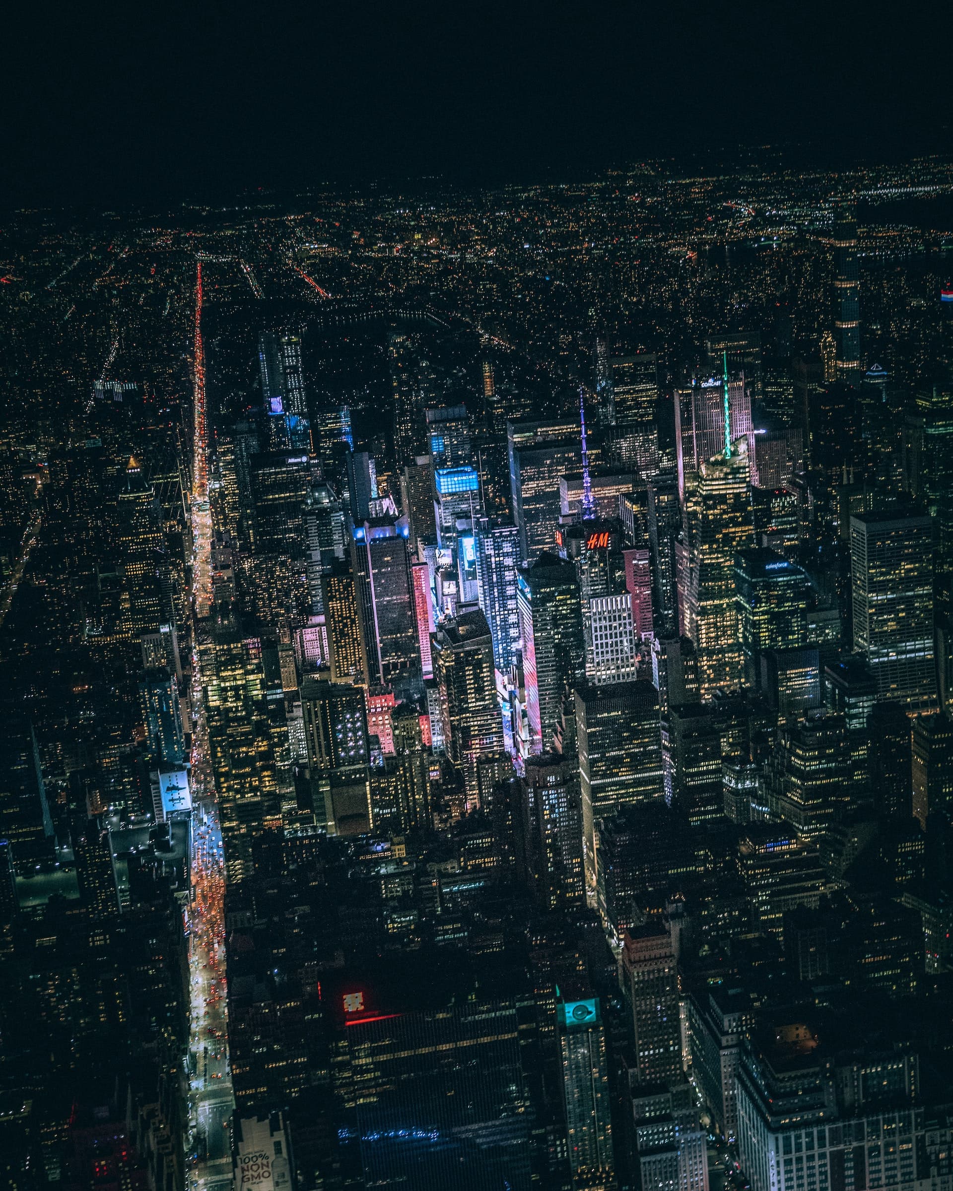
Everyone enjoys looking out of the window whenever they get an opportunity to sit in a window seat while traveling on a flight to a new city. The first time I visited New York, I was curious about the new world where I was supposed to start a new life and began staring out of the window to anticipate what the city had in store. As the flight started to descend through the clouds towards the airport, the first glimpses of the big apple started to appear.
The tall buildings of Manhattan and Brooklyn are spectacular, yet it is nearly impossible to ignore at first how the streets are neatly arranged on the island. A clean grid of blocks of residential and commercial buildings, pencil towers, and low-rise brownstones, all set in a tapestry. The streets run across the island like men marching in a platoon. They span across the width and length of the islands, starting at one end and culminating at the other. Each street meets the other at right angles as they cut through and keep marching towards the end.
Seldom do these straight lines stray away from their path and make some ambiguous turns and veer off from their monotony. Broadway and Downtown Manhattan are a few such examples. Despite such anomalies, the city of New York seems to have grown with some obsessive compulsion to follow the linearity. There is unnerving conformity of the buildings to the grid, the way it has been developed.
Grid layouts of a city make me uncomfortable sometimes. One of the most specific reasons for this discomfort was the first time I visited Manhattan. I was trying to reach a particular hotel on 42nd street, and it took me a while to get there as I kept going around in circles around the hotel after reaching Manhattan for more than an hour. The sheer heights of the buildings were overwhelming, and the sky was barely seen. Standing at the crossing, it was complicated to fathom if I was moving towards downtown or uptown. The street ran both ways, and I tried to make sense of my direction. It was not a pleasant experience. However, everyone around me seemed clear about where they were headed. The people on foot were fast and efficient. They were confident in their orientation and highly familiar with the surrounding, the locations, corners, the junctions and parks, the waterfront, the subway, and eventually the milieu of which they have been a part for a longer time.
This paper begins its journey by understanding New York’s Street grid ecosystem and identifying the phases of its development and the impact on the organisms that inhabit this complex ecosystem.
EVOLUTION OF THE NEW YORK STREET GRID
The grid plan, also known as the grid street plan or gridiron design, is an urban city plan in which streets are laid out in a grid. This planning method has been used historically across the world and is still used today. In the Indus Valley Civilization, the cities of Mohenjo-Daro and Harappa were built with blocks split by a grid of straight streets that ran north-south and east-west. In Giza, Egypt, around 2500 BC, workers were housed in a workers’ town built out in blocks of long galleries divided by streets in a systematic grid. A north-south axis from the royal palace and an east-west axis from the temple met in a central plaza where King and God blended and crossed in many pyramid-cult towns. In the 18th century BC, Hammurabi, the monarch of the Babylonian Empire, ordered the reconstruction of Babylon, including the construction and restoration of temples, city walls, public buildings, and irrigation canals. The streets were large and straight, intersecting at right angles and covered with bricks and bitumen.
Architects and Urban designers worldwide have repeatedly come across the grid plan in their lives. New York City came across this grid plan for the first time at the beginning of the 19th century, in the form of the Commissioner’s plans of 1811. Up until the 18th century, Manhattan had evolved in an unregulated manner, and the common Council was seeking ways to provide for an orderly development for the city, which would allow the Council to avoid debates that arise out of land sales and boundary issues. It was also expected that the plan would help the Council address critical health issues arising from poor sanitation and disposal of waste.
When New York’s Common Council began to take jurisdiction over the city’s cityscape, they began issuing measures to keep the streets clear and required new streets to be authorized in advance. They also started levying assessments on property owners to cover the expense of maintaining the roadways. Beginning in 1803, the Council started to eradicate roadways that served no public use and took responsibility for street construction, which was previously constructed by private property owners.
The 1811 plan, when released, looked like a clean slate with a grid for further development. It kept track of an ordering system. The grid terminated at number 155, and thus the streets are numbered 1 to 155. The Common Council minutes noted issues in lower Manhattan caused by duplicative street names. Numbered streets remedied this problem by replacing a descriptive system (Broad Way, Bleecker Street) with an abstract, measured order.
The grid appears uniform at first glance, yet it has two patterns that add diversity. The widths of the streets create one pattern. The avenues are 100 feet wide, with a 60-foot typical cross street and a 100-foot large cross street. These street proportions were larger than the standards in lower Manhattan, where broad streets were 40 to 50 feet wide. The second pattern is based on block measurements: all blocks are 200 feet long north to south, but their east to west dimension is varied, with the breadth decreasing from the island’s center to the shorelines. The Commission explained that the motive of the plan was to provide right angled houses, unlike the homes in the lots of a radial or star-shaped city. It helped reduce the construction cost and made the city a convenient place to live in.
The Commissioner’s plan of 1811 received staunch criticism. In Thomas Janvier’s book In Old New York, the idea was described as “only a grind of money-making” (1894). These are individuals who would have torn down the seven hills of Rome,” one commentator even said in 1818, referring to the idea. Despite its flaws, the strategy has recently received positive feedback. One critic recently pointed out that, among other things, the large avenues and streets encourage retail and commercial use.
Before the 1811 plan, the city’s development was unregulated. This was the first attempt in New York to lay order to the way this city was planned and gave rise to smaller ecosystems in the city.
THE CAPITALIST INTERVENTION
To understand if this grid gave rise to a capitalistic ecosystem, we could start by trying to understand if there was any kind of economic benefit that resulted from the implementation of the New York grid. One of the primary reasons for the development of the grid was cited as ‘to provide for orderly development and sale of land. This was crucial since the Council could not achieve this goal due to local politics and objections from property owners. Private developers in Manhattan had already laid precedents for rectangular grids; King’s college had laid out a neighborhood in rectangular blocks in the early 1750s. De Lancey family had decided to break up their large estate and eventually laid out a rectangular grid of streets centered on De Lancey Square. The Romans used the centurion method to measure land for sale and avoid disputes. The 1784 plan by Thomas Jefferson also used rectangular divisions. The rectangular division offers advantages of simplicity and a standard of measurement, allowing easy facilitation of the sale or marketing of land. The creation of the grid system in New York was expected to raise the value of the land, which turned out to be a lucrative proposition as more land was allotted to the streets in the grid compared to that of unplanned development. It also allowed for the purchase of large-scale plots by combining adjoining lots. Since the blocks are surrounded on all four sides by streets, it facilitates the use of commercial activities. As the surface area abutting the road increases, the opportunity for commercial development enhances. This is evident even today from the prevalent retail prices - another catalyst to raise the value of the lot or the block. However, the implementation of the grid did attract a host of arbitrations and disputes, which were settled either by compensation or relocation.
One factor is extremely crucial to consider. The division of land into grids provides order to its distribution. This order further culminates in recognition of each inhabitant and provides every organism of this milieu with a unique identity to which the sold lot of land can be immediately connected. The lot number and the street number made it easy to identify everyone in the city. As mentioned earlier, the Commission was thus able to levy the costs of the infrastructure development directly onto the residents. It also allows the city to collect recurring taxes on behalf of every lot within the grid. This seems like an inconvenient trade off between the city and the residents, as it marks the beginning of a new era with the grid, which will eventually come to be known as one of the greatest cities of the world with the promise of a bright and healthy future. Simultaneously, it also adds to the cost of living for its residents. During this time, more than twenty thousand immigrants occupied the island of Manhattan in squatters and shanty towns. These immigrants were considerably neglected during the development of the grid and had to relocate to the fringes of the grid. This meant that the inhabitants of these squatters and shantytowns would need to travel larger distances to reach their place of employment and spend more time commuting from one place to another, as well as face the perils of commuting through unsafe conditions like poor visibility and extreme weather conditions in order to meet their daily needs. Years of research and case studies have proven that human capitalistic behavior is most likely to discard the ramifications of environmental degradation as well as marginalized communities. The New York grid once again proves that the ecological conditions of the terrain were severely ignored. In order to maintain the two-dimensional cartographic representation and make way for the street grid, the Commission had to make drastic changes to the existing terrains, and large bedrock formations and outcroppings were cleared. This process took almost 60 years to complete. While these are very small examples to base a critical conclusion, the grid did, in fact, impact the organisms and the environment even as it led to economic benefits.
To summarize, a few severe modifications to the terrain and disregard for the environment helped raise a stable source of income for the city by means of regulatory taxes and sale of lots, accommodation of developer’s and retail owner’s interests, and the suburbanization of squatters and shanty towns. All these aspects do point out neglect on the one hand and an ecosystem of stable benefit in the hands of the governing authorities as well as the wealthy residents of the city. A practice that has manifested into the division of the city into smaller neighborhoods whose identity can be determined by the economic conditions of rich and poor or by the country of their immigration.
The capitalistic ecosystem of the New York grid is still playing an important role in the way the city is ordered and divided, which can clearly be seen even today in the soaring prices of real estate.
GRID AS A CULTURAL TECHNIQUE
Bernhard Siegert defines the grid as a cultural technique. The shorter version of the definition reads, “The grid, in short, is a medium that operationalizes deixis. It allows us to link deictic procedures with chains of symbolic operations that have effects in the real. Hence the grid is not only part of a history of representation or of a history of procedures facilitating the efficient manipulation of data but also of “a history of the different modes by which, in our culture, human beings are made into subjects.”
New York’s grid system, with its adaptation, creates ground for a new city by means of which the technological aspects of the grid start seeping into the culture while making the inhabits into subjects that can be governed and manipulated.
The implementation of the grid allowed every one of the city to be converted into subjects by allotting everyone with an identity and address, converting the two-dimensional representation of subjects that could be manipulated. In today’s context, we can see that the grid has helped the city evolve into a place where an address can be easily located, letters can be posted to accurate locations, and bills and e-commerce can work efficiently with the simplicity of the grid. Traffic management becomes much easier as it avoids bottlenecks, and health and emergency services can reach faster to any point in the city.
The collection of important aspects of information such as census data and income estimates has been made easier with the conformity of the grid to the rectangular shapes. The smallest unit of the grid block starts taking a culture-defining role when its residents come together to form community blocks and join efforts to bring about change within the blocks for its security or other social aspects of community living. It also allows the city to be divided into clear forms of jurisdictions for political control, which can be seen with the gerrymandering maps. It also allows for the blocks to be divided into precincts to maintain law and order. Unplanned cities face a much larger issue when such divisions of public services are to be implemented due to the ambiguousness of their boundaries. The New York grid makes it much easier due to the nature of its rectilinear grid and allows for a clear distinction within different boundaries for different jurisdictions.
A similar form of culture evolves with the location of parks and monuments, and plazas within the city. The location of such zones of interaction on the grid also, in a way, reflects upon the culture of the areas surrounding. Locations like Times Square and Central Park become symbols of identification for the city through movies and popular culture. Locations like Chinatown and Little Italy, where earlier immigrants settled, are now a cultural identity of this place.
The sidewalks and the corners also become a new form of ecosystem , where the store fronts displays attract prospective customers, cafes and restaurants lay out chairs and table to enjoy a meal in the street while being a part of it. The rectilinear grid of New York has one shorter side and another longer, which starts to form more number of intersections and corners for the community, where people come together as a community.
While the technology seeped into the culture through the grid, it also allowed for identifying the differences in economic status and ethnicity of its residents’ distinguishing neighborhoods from one another. Segregation became a critical tool since it was easy to identify the poor and marginalized through income and census data collection. Robert Mosses’ policies are one such example where we could find the bias and how the grid at the same time also helped to marginalize and suburbanize the residents of the city.
The grid eventually had a very severe impact on how the evolution of New York has shaped throughout the last few centuries. And how the technology has seeped into the culture of its residents.
GRID AS A MEANS OF ENVIRONMENTAL CONTROL
In Banham’s essay, “A Home Is Not a House,” he offered a scheme to consider architecture from the point of view of environmental control and prioritize the characteristic of Mechanical services. While his exploration continued to create the environment Bubble or the transportable standard of living package, the illustrations created by Mary Banham exposing the internal mechanical services of the buildings show the true mechanistic nature of architecture.
To understand how this idea of architecture as a machine is illustrated by the drawings of Banham. We can try to expose the hidden underground network of environmental services laid out in the city as we see today. The Commissioner’s plan only considered two elements, the block, and the street. But it indirectly starts to seep into the different ecosystems as it starts to directly influence the urban life and culture as well as the utilities, transport networks, and the social patterns that follow the grid.
The earlier grid was laid out on potentially vacant land, and unpopulated areas, the mechanical systems mentioned above also developed simultaneously along the geometry of the rectilinear grid. Let us consider the transportation network to begin with. Today we see the street traffic move with ease and with a direction. We cannot ignore the frequent congestions but at the same time we can also see that it poses a less severe problem as compared to streets with two directional traffic. The Commissioner’s plan allowed the movement in both directions, until 1949 the Transport department engineered a solution to increase the capacity of the streets and avenues to sustain more traffic.
The solution involved the use of one-way streets within the grid layout. The width of street in the north south direction was 100 feet and east west was only 60 feet, which was further shared with the sidewalk on both sides or the right of way. Permitting vehicles to move in both directions would lead to congestions as the capacity of the intersection to handle the complex exchanges in the directions of each motor vehicle vastly increases, when it must address traffic from four directions. Changing most of the streets and avenues into one direction reduced the effective load of traffic on the intersection. The reduced loads further help to clear congestions and bottle necks in a fast and efficient manner. Making this system of vehicular management into a well-oiled machine that functions around the clock even today.
Just like the vehicular traffic, the trains shared a section of the street grid and were placed on the grade level. The blizzard of 1888 with its 40-inch snow and 200 casualties halted all public transport and affected the supply of produce, mail as well as coal to the city. As a city New York has faced severe climatic conditions in the past consistently, such as blizzards and floods. But the blizzard of 1888 which brought the entire city to standstill, forced the city to imagine a different method of transport, which is not affected by the extreme conditions. The placement of the subway lines below ground would solve the problem and permitted an effective method of climate control with subway network within the grid.
The proposition to place the subway underground would require for a large-scale infrastructure change and would require a long time to complete. The project was undertaken in the early decades of the 20th century, and it had eventually disrupted the daily lives of several residents as construction continued. One of the primary methods adopted for construction was called cut and cover, which involved the excavation of the street and laying of concrete trenches within which the tracks for the trains would be laid and then the entire trench was covered with a roof and the street. The use of cut and cover meant that the network of subways would require to be place within the width of the street. It did not involve disputes and litigations since the grid became a part of the social and public infrastructure and no ownership could be established. At the same time, it also meant that the city did not require to buy back the land for construction. Today we see complex network of subways that follow the grid as far as it can. It will not be an understatement to consider the subway network of New York as the workhorse of the transport ecosystems. It also provides a means of livelihood for the residents and shelter for the homeless in emergencies.
A similar pattern can also be seen emerging in the way the electrical cables that were laid out in the city. The 1888 blizzard was also instrumental in uprooting electrical connections, streetlamps, it also affected the communication lines such as telegraph and telephones. The gas companies had already laid out their metal pipelines underground since the distribution was largely central, and these lines already followed the grid. In a similar manner the electrical lines which connected by means of shallow trenches that were connected to the streetlamps and the adjoining network of occupied lots or units in the block. Most of the connections provided to units were in the form of an intricate network of cables that were hanging above the street. After the blizzard, the communication lines were rendered unusable by the weather. The electrical lines were relocated to move underground and follow the grid under the cut and cover method. Even steam energy for heating was also supplied in a similar underground manner.
If one was to expose the services of the ecosystem of the grid, we would be able to represent the services of environmental control such as steam heat, electricity, and gas, which were the primary services provided centrally, and give a representation that will closely illustrate Banham’s environmental control diagrams. The only difference was that Banham’s focus was restricted to a singular building or unit. Still, it was possible to visualize the city’s entire ecosystem along the lines of his diagrams for environmental control.
GRIDS AS BLOCK OF SEGREGATION
The New York street grid, considered one of the greatest grid systems, fails to address the critical question of segregation. As technology seeped into the culture through the grid, it also allowed for identifying the differences in economic status and ethnicity of its residents’ distinguishing neighborhoods from one another. It allowed for identifying the poor and marginalized through income and census data collection. Robert Mosses’ policies are one such example where we could find the bias and how the grid at the same time also helped to marginalize and suburbanize the city’s residents.
In Red Hook, the infrastructural and Constructed divisions of the street grid by the BQE facilitate a division of the community from Brooklyn. The abrupt discontinuity makes it more likely to be inaccessible than welcoming. The structural scale of elevated bridges and a complex network of roads beneath the bridges, along with the tunnels and underpass, start forming a virtual divide.